Editor’s Note: Follow the latest on the bomb cyclone here. This story is no longer being updated.
A “once in a decade” bomb cyclone lashed the northwest United States and parts of Canada early Wednesday with hurricane-force wind gusts –– leaving at least one person dead and hundreds of thousands without power across Washington state, California and British Columbia.
In Seattle and neighboring cities, strong winds are tumbling trees, with some falling on houses and placing lives at risk.
In Lynnwood, north of Seattle, a woman in her 50s was killed when a large tree fell on a homeless encampment shortly after 7 p.m. PT, South County Fire Department told CNN.
More than 650,000 customers lost power in the early hours of Wednesday in Washington, while about 140,000 customers were without power in British Columbia, BC Hydro reported on its website. As of midnight PT, over 24,000 customers in California were without power.
The National Weather Service has reported notable wind gusts across the region, including off the coast of British Columbia, where winds were blowing at 101 mph at the South Brooks Buoy.
Gusts of 72 to 77 mph were recorded in Washington state, including at Cape Elizabeth on the Olympic Peninsula and at Crystal Mountain and Sunrise-Mount Rainier inland southeast of Seattle.
“It’s severe out there. Trees are coming down all over the city, with multiple falling onto homes,” the fire department in Bellevue, east of Seattle, posted in a Severe Weather Safety alert on Facebook. “If you are able, head to the lowest floor you can and stay away from windows. Do not go outside if you can avoid it.”
Videos obtained by CNN show multiple fallen trees on power lines in Lake Stevens, Snohomish County, north of Seattle, with Snohomish Regional Fire and Rescue saying that there are “many trees and power lines down.”
In Maple Valley, a city southeast of Seattle, two people were rescued after a tree fell on their trailer, according to Puget Sound Fire. One patient was freed quickly, while it took firefighters an hour to extricate the second. Both patients were transferred to a nearby hospital.
An Amtrak train collided with a fallen tree near an intersection in Stanwood, north of Seattle on Tuesday night, according to CNN affiliate KIRO. The incident left the train inoperable, though none of the 47 passengers on board sustained injuries, KIRO reported. CNN reached out to Amtrak for more information.
Several school districts in western Washington will be closed or delayed on Wednesday due to the impact of the storm.
“Due to widespread power outages, fallen trees, and high winds in some areas, all school buildings will be closed on Wednesday, November 20th, and all after-school activities have been canceled,” the Eatonville School District, 60 miles south of Seattle, shared on social media.
Across western Oregon, winds of 30 to 50 mph were reported with gusts along the coast and offshore reaching over 70 mph late Tuesday. In Northern California, gusts offshore reached 60 mph with the high peaks in Humboldt reaching 80 mph.
‘Bombogenesis’

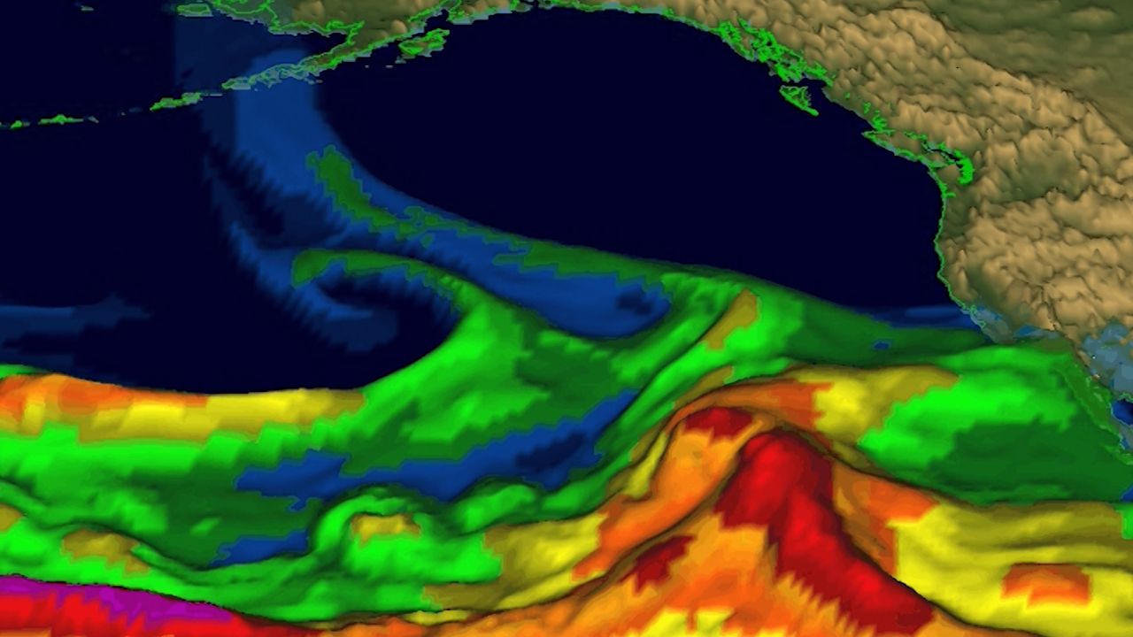
The powerful “bomb cyclone” will combine with an atmospheric river to unleash over a month’s worth of rain, hurricane-force wind gusts and feet of mountain snow to parts of the Pacific Northwest and Northern California.
The storm system rapidly intensified on Tuesday in a phenomenon called “bombogenesis” and earned it the moniker of “bomb cyclone.” This was one of the most intense on record for its location, a storm that occurs only “about once every ten years,” the National Weather Service in Medford, Oregon, said.
Bomb cyclones are formidable and unload heavy snow and strong winds during the winter.
This bomb cyclone will work with an atmospheric river, a long plume of water vapor moving like a river through the atmosphere, to wring out heavy rainfall and significant mountain snowfall in the Pacific Northwest and Northern California. The pair will stall along the coast and hammer the area with hazardous conditions through the week and into the weekend.
Parts of northwestern California could record 16 inches of rain or more in 48 hours. More than a month’s worth of rain is expected in the northern San Francisco Bay area, primarily north of the Golden Gate Bridge, the weather service there said. Rainfall of this magnitude is expected to cause significant urban flooding, debris flow on roadways and river flooding.
The heaviest rainfall is expected to begin Wednesday and peak Thursday across northwestern California. A level 3 of 4 risk of flooding rainfall is in effect there for Wednesday and a rare level 4 of 4 high risk is in place for Thursday, according to the WPC.
It’s hard to overstate how big of a deal these high risks are. They are issued on fewer than 4% of days per year on average, but are responsible for more than 80% of all flood-related damage and 40% of all flood-related deaths, research from the WPC shows.
Three to 6 inches of rain could fall Wednesday with some spots getting up to 8 inches. Thursday’s rainfall could meet or exceed Wednesday’s totals, especially in the high risk area.
Heavy snowfall is expected across higher elevation areas, where winter weather alerts are in place. Blizzard warnings are in effect across parts of the Washington Cascades, where snowfall over a foot and gusts of up to 60 mph are possible through Wednesday morning.
“Travel could be very difficult to impossible. Strong winds could cause extensive damage to trees and power lines,” the National Weather Service office in Seattle warned.
One to 4 feet of snow is possible through Wednesday across the Cascades and the northern Sierra Nevada. Snowfall could create impossible travel conditions on Interstate 5 and Highways 31, 36, 66, 89, 97 and 140.
Powerful winds peaked Tuesday for much of the Pacific Northwest as the bomb cyclone began to weaken, but conditions will remain gusty across the region Wednesday.
Conditions will start to improve by the weekend, but lighter rain could continue into next week.
CNN’s Isaac Yee and Hanna Park contributed to this report.


