Editor’s Note: For the latest updates on Memorial Day weekend storms, our coverage has moved here.
(CNN) – The National Weather Service has issued a tornado watch for parts of three states, labeling it a “particularly dangerous situation,” a rare designation indicating the possibility of exceptionally strong storms.
The tornado watch covers parts of northern Texas, much of central Oklahoma and south-central Kansas. It will expire at 11 p.m. CT.
The watch calls for several tornadoes – a few intense ones likely – over an area that includes cities such as Wichita, Kansas, and Oklahoma City, Oklahoma, according to the Storm Prediction Center.
This is a special kind of tornado watch issued only when there’s unusually high confidence in the potential of multiple at least EF2-strength and long-lived tornadoes in the area, according to the National Weather Service.
Another tornado watch was added to portions of Kansas until 1 a.m. CT, affecting half a million people, according to the Storm Prediction Center. More than 4.5 million Americans were under tornado watches Saturday evening.
The supercell thunderstorms firing up in the watch area will also be capable of extremely large hail up to the size of grapefruits and damaging wind gusts to 80 mph.
An EF4 tornado – the third such violent tornado this year – killed at least four people in Greenfield, Iowa, Tuesday and left parts of the city in ruin. More strong tornadoes – at least EF2-strength – are possible Saturday in parts of the Plains and Sunday in portions of the Midwest.
Some tornadoes Saturday could be particularly violent and exceed EF4-strength, the Storm Prediction Center warned Friday.

Supercell thunderstorms that began firing up Saturday could be capable of producing a couple tornadoes, scattered large hail up to the size of softballs and damaging wind gusts to 70 mph, according to the Storm Prediction Center.
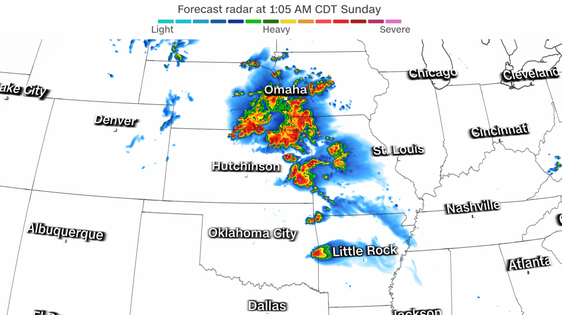
Dangerous storms are expected to rumble to life in the evening in parts of western Nebraska, Kansas and Oklahoma. Storms will expand in both scope and strength in the evening and overnight and move east into the Mississippi Valley.
A Level 4 of 5 risk of severe thunderstorms is in place Saturday for a large swath of Kansas and Oklahoma, including Oklahoma City, Tulsa and Wichita, and far western Missouri.
“Violent tornadoes, extreme hail and corridors of widespread wind damage” are most likely within this area, according to the SPC, but could extend beyond it. Anywhere from Texas through Nebraska to the Mississippi Valley could encounter storms unloading strong wind gusts, hail and tornadoes.
Robust thunderstorms will continue over parts of the Mississippi Valley through Sunday morning before gradually losing their strength. But a new round of damaging storms is expected to arrive quickly after.
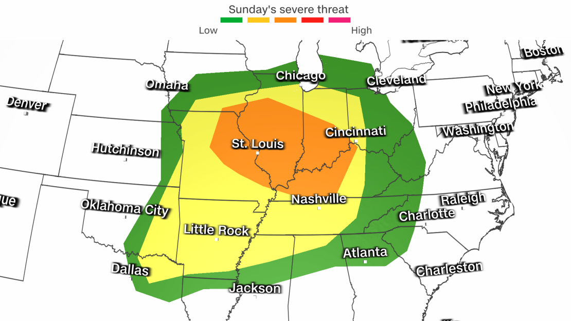
Thunderstorms will develop over portions of the Midwest by Sunday afternoon and develop farther south and east through the evening and overnight hours. Powerful storms could ultimately stretch from the Great Lakes to the South Sunday night.

Damaging wind gusts and hail will be the main hazards with any severe thunderstorm Sunday, but some could produce tornadoes. At this time, the greatest tornado threat is in parts of the Midwest, especially during the afternoon and evening.
The travel hubs of Chicago, Indianapolis, St. Louis and Nashville could have to contend with damaging storms, leading to delayed or cancelled flights.
Thunderstorm activity will likely continue for Memorial Day Monday and could disrupt outdoor plans and travel for a large part of the East. Some of these thunderstorms could become severe, but it’s not yet clear how widespread the threat will be.
Even in the absence of damaging wind gusts, hail or tornadoes, lightning is a serious threat for any outdoor plans like picnics, pool parties or beach trips.
Unofficial start of summer will officially feel like summer
Meanwhile, dangerous storms and searing heat will continue affecting vast portions of the United States this Memorial Day weekend and could disrupt outdoor plans and travel.
A near-record number of people will travel this weekend in what could be the busiest period in nearly two decades, according to AAA.
Travelers will have to contend with a hazardous and disruptive multi-day severe thunderstorm event with damaging winds, dangerous hail and strong tornadoes. It is expected to unfold this weekend in portions of the central, southern and eastern US.
Severe weather has been unrelenting in May, but hit an even more frenetic pace this week. Nearly 850 wind damage reports and at least 80 tornado reports have occurred across the US since Sunday.
While severe storms pound inland areas this weekend, some coastal areas will face a different threat. A heaping serving of summerlike heat is on the menu as many head to the beach to celebrate the unofficial start of summer.
It’s already been record hot in parts of the South this month, especially in South Texas and South Florida, the type of extreme heat made more likely by human-caused climate change.
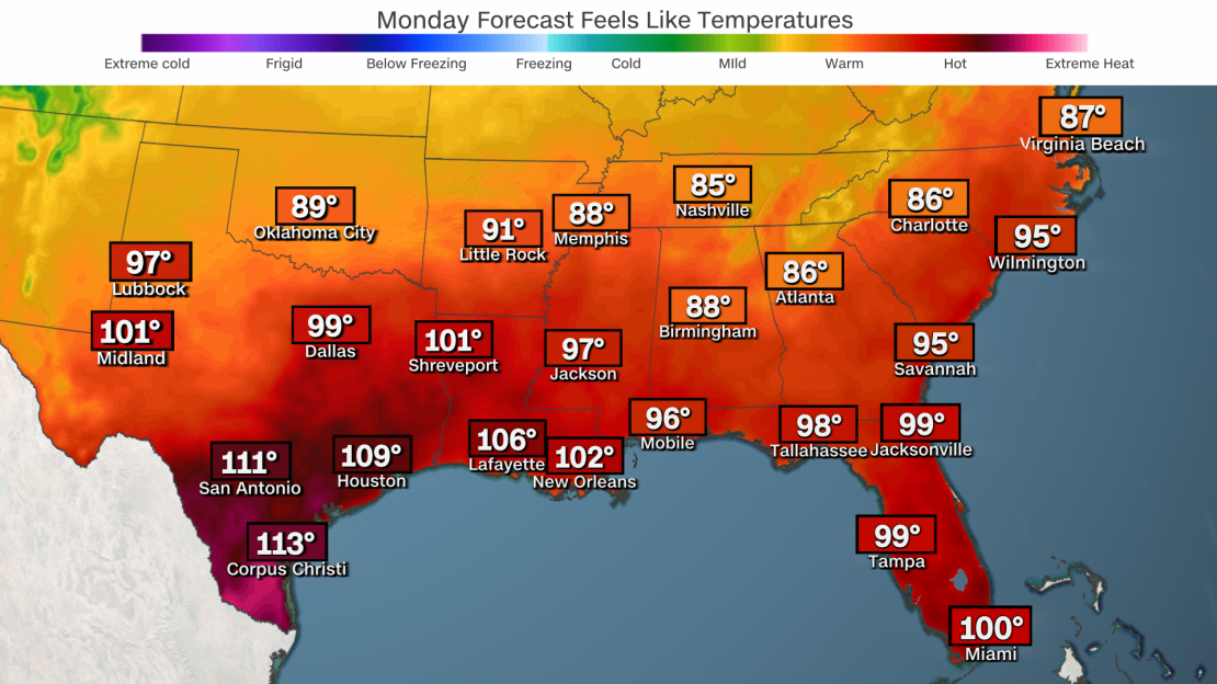
Record heat will expand over the weekend and jeopardize daily high temperature records in jeopardy from Texas through the Southeast as air temperatures soar well into the 90s.

Houston, New Orleans, Miami, Mobile, Alabama, Tampa, Florida, and Charleston, South Carolina, are just a few cities along the Gulf and southeast Atlantic coasts where it’ll feel more like July than late May through Memorial Day.
The heat index, which measures what the body actually feels, could approach triple-digits along the southern tier of the US, raising health risks from weather’s deadliest threat.
For those out in the heat, it’s important to stay hydrated and be vigilant for signs of heat exhaustion or heat stroke.
Heat index values skyrocketed well into the 100s this week in southern Texas and could climb higher into seriously dangerous territory through Monday. The heat index is expected to max out between 110 and 120 degrees in southern Texas, including in Corpus Christi and Laredo, according to the National Weather Service.


