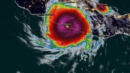
The rapid intensification Hurricane Otis underwent in the hours before it slammed into southern Mexico is a symptom of the human-caused climate crisis, scientists say – and one that is becoming more frequent. When it happens right before landfall, as it did with Otis, it can catch coastal communities by surprise with little time to prepare.
The hurricane’s intensification was among the fastest forecasters have ever seen: its top-end windspeed increased by 115 mph in 24 hours. Only one other storm, Hurricane Patricia in 2015, exceeded Otis’ rapid intensification in East Pacific records, with a 120-mph increase in 24 hours.
The term rapid intensification refers to when a storm’s winds strengthen rapidly over a short amount of time. Scientists have defined it as a wind speed increase of at least 35 mph in 24 hours or less, and it generally requires significant ocean heat. The National Hurricane Center said Otis strengthened so fast on Tuesday that it had “explosively intensified.”
Otis “took full advantage of a warm patch of ocean” that was roughly 88 degrees Fahrenheit, said Brian McNoldy, an atmospheric scientist at the University of Miami – more than enough ocean heat to fuel a monster storm.
More than 90% of warming around the globe over the past 50 years has taken place in the oceans, according to the National Oceanic and Atmospheric Administration. In addition, an El Niño is growing in the Pacific this year, driving ocean temperatures even higher.
Otis’ strengthening “was extremely unusual,” McNoldy told CNN. “It’s unfortunate it happened right before making landfall, but if this had occurred over the open ocean, it still would have been very remarkable.”
Tropical storms usually take several days to grow into powerful hurricanes, but with human-caused climate change, rapid intensification is becoming a more common occurrence, said Suzana Camargo, hurricane expert and professor at Columbia University’s Lamont-Doherty Earth Observatory.
“It’s very rare for intense storms to make landfall in Mexico’s eastern Pacific side,” Camargo told CNN.
Only one hurricane, Category 1 Hurricane Max in 2017, has made landfall within 50 miles of Acapulco, according to a CNN analysis of NOAA data.
“But we have an El Niño year, which makes the eastern north Pacific Ocean more active than normal, and on top of that you have anthropogenic climate change,” Camargo said.
The alarming rapid intensification trend has also been reported in the Atlantic.
A recent study found that Atlantic hurricanes may now be more than twice as likely to strengthen from a weak Category 1 storm to a major Category 3 in a 24-hour period than they were between 1970 and 1990.
A 2019 study found that between the 1980s and early 200s, Atlantic hurricanes showed a “highly unusual” increase in rapid intensification – a trend the report said could only be explained by human-caused climate change. And, concerningly, scientists found significant intensification was happening to the strongest storms, making the most life-threatening hurricanes even more dangerous.
Rapid intensification has been historically hard to predict, but with climate change making oceans warmer, scientists are confident it is a phenomenon that will occur more often.
“All of this is just confirming what we expected,” Camargo said.


