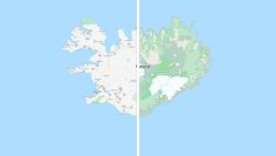
Google Maps is getting a colorful, more detailed redesign.
Google’s new “color-mapping algorithmic technique” will help people more easily distinguish different types of terrain from tan beaches and lush green forests to varying types of blue for lakes, oceans and ravines. The update is rolling out immediately to users in 220 countries that have access to Google Maps.
“This update is visible no matter what area you’re looking at — from the biggest metropolitan areas to small, rural towns,” Google (GOOGL) said in a post announcing the changes Tuesday.

To accomplish this, Google analyzed advanced satellite imagery and assigned more detailed colors to different types of areas. So, a forest now has dark green while a lighter patch of grass, like shrubs, has a lighter shade of green. People can even see snow caps in the mountains.
But it’s not limited to nature: Google is also using the technology on city streets. Beginning soon in New York, London and San Francisco, streets, sidewalks and pedestrian islands will be redrawn so people can see them more clearly.
“These details are particularly helpful as more people are opting to walk or take other forms of solo transportation due to the pandemic,” Google said.

Other cities will get the terrain updates “over time,” it said.
This week’s redesign is the second major facelift this year. Google Maps placed a greater emphasis on discovery and recommendations, along with a new logo, in a February update to celebrate its 15th birthday.


