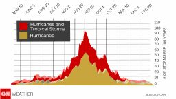
Hurricane Florence has weakened to a tropical storm but will likely strengthen again into a major hurricane and could threaten the US East Coast by next week.
On Wednesday, Florence became the first major hurricane of the 2018 Atlantic season, with maximum sustained winds peaking at 130 mph, making it a Category 4 hurricane, according to the National Hurricane Center.
Track the storm and compare different forecast models

But increased wind shear over the open Atlantic – the storm is about 1,500 miles from the East Coast – weakened Florence to a tropical storm, with 65-mph winds as of 5 a.m. ET Saturday.
Wind shear will lessen over the weekend, and Florence should regain major hurricane intensity (Category 3 or greater) by early next week – as the storm moves northwest, getting closer to the US coastline by the day.
It’s too early to tell if the storm will make landfall somewhere on the East Coast, or if it will turn harmlessly back to sea.
Still, there are some troubling signs in the major computer models that meteorologists use to predict hurricane tracks a week or more in advance.
The European and American models have shifted westward, consistently showing a menacing hurricane coming dangerously close to the Eastern Seaboard.
Florence should track south of Bermuda early next week but will be close enough to bring gusty winds and dangerous surf conditions. Large swells will also begin affecting the US Southeast coast, with larger waves and rough surf as early as this weekend, increasing through next week.

Florence’s track will depend on the development and movement of a number of weather systems as the storm gets steered by a large ridge of high pressure in the Eastern United States and northern Atlantic as well as the progress of a low pressure trough across the country.
As a precaution, North Carolina Gov. Roy Cooper issued a state of emergency Friday so that farmers could harvest and move crops more quickly, waiving certain transportation restrictions.
CNN meteorologist Judson Jones contributed to this report.


