The Atlantic hurricane season is shaping up to be “below-normal” with five named storms – but it’s the Pacific that is turning out to be more menacing as Hurricane Lane is the 12th named storm in the region.
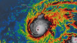
After a catastrophic hurricane season last year, many dreaded what this Atlantic hurricane season could bring. In the Pacific, Category 4 Hurricane Lane is barreling toward the Aloha state in a rare threat to the Hawaiian islands.
Lane comes just weeks after Hurricane Hector, also a Category 4 storm, alarmed state officials. Hector ended up passing south of the state. While the forecast for Lane still remains uncertain, authorities are warning that it could make landfall in the Hawaiian islands in the coming days and Gov. David Ige urged residents to prepare 14 days of food and water.
There is a yin and yang aspect to tropics when looking at cyclone formation in the Atlantic and Pacific Ocean basins. When one is active the other is quiet and there is a correlation as to why with many environmental factors.
Hurricane Lane is a rare occurrence in the Pacific
Although it’s not always heard about, the Pacific can get a lot of hurricane activity – more so than the Atlantic, said Phil Klotzbach, research scientist in the department of atmospheric science at Colorado State University.
“Most of those storms just go out in the middle of nowhere and die in open water,” Klotzbach said.
These don’t make landfall and doesn’t affect people, so doesn’t end up making headlines. But once in awhile, a major storm like Lane can come by.
Warmer waters help create a perfect storm
One of the factors behind this year’s active Pacific hurricane season is that the water is warmer, he said.
“When the Pacific is warmer than normal, it tends to alter winds in such a way that you increase vertical wind shear over the Atlantic,” Klotzbach said. “So you get more shear in the Atlantic, which tears apart the hurricanes and you get less shear in the Pacific.”
Wind shear is bad for hurricanes, because if there’s a lot of wind surrounding it, the weather systems have trouble organizing and developing into a tropical storm. If there’s no wind shear, the storm can keep turning, keeping intact and gaining strength, according to NOAA.
But with Hurricane Lane, the shear has been very low allowing it to intensify, Klotzbach said.
In general, the Pacific side has had low wind shear and warmer waters, which are conducive for storms. NOAA’s Central Pacific Hurricane Center predicted an 80% chance of a near- or above-normal hurricane season.
What about the Madden-Julian Oscillation?
Other factors have also played a role in a quieter Atlantic hurricane season and a more active Pacific season.
There is a large scale atmospheric phenomenon called the Madden-Julian Oscillation (also known as the MJO) which can suppress or enhance tropical cyclone development. The MJO is considered a large scale tropical disturbance that circles the globe every 30 to 60 days.
During an active or convective phase of the MJO, tropical cyclone activity is greater due to enhanced uplift in the atmosphere. Therefore, more wet and stormy conditions are observed.
Warmer sea surface temperatures can also impact the intensity of a convective phase of the MJO.
For much of July, the Western Pacific was in a convective phase, which shifted more toward the eastern and central Pacific at the beginning of August. Thus, more storms in the Eastern and Central Pacific, as well as an active east Pacific season.
The Atlantic and Caribbean have been in a suppressed phase which, in conjunction with the Saharan Air off the African coast and enhanced shear, have caused the Atlantic season to be quiet.
There is a ‘seesaw’ between the Atlantic and Pacific
The activity between the Atlantic and the Pacific hurricane seasons is “kind of like a seesaw,” Klotzbach said.
“When the Atlantic is active, the Pacific tends to be quiet. So last year, it was pretty quiet in the Pacific. And then this year obviously, the Atlantic has been pretty quiet so far… and the Pacific tends to get really active in these situation.” Klotzbach said. “A lot of that is due to inverse relationship between the hurricanes and how they respond to El Niño events.”
It’s likely that El Niño will form during this year’s hurricane season. El Niño brings warmer water in the eastern Pacific equatorial region and decreases vertical wind shear over the tropical central Pacific. But it creates greater wind shear in the Atlantic, and thus, fewer tropical storms there.
“It is very important to remember that it only takes one landfalling tropical cyclone to bring major impacts to the State of Hawaii,” said Chris Brenchley, director of NOAA’s Central Pacific Hurricane Center in a statement in May.
Just because there hasn’t been much activity in the Atlantic this year, it doesn’t mean the coast is clear. The peak time for Atlantic hurricane activity is September.


