Editor’s Note: A version of this article originally appeared in the weekly weather newsletter, which is released every Monday. You can sign up here to receive them every week and during significant storms.
The Storm Prediction Center (SPC) chooses its words carefully. And when they say, “A regional severe weather outbreak – including potential for significant/damaging tornadoes – remains evident,” they believe a dangerous and robust storm system is taking shape.
“SPC Outlooks use phrases such as have been used over the past few days only when environmental conditions appear supportive of more widespread and higher-end severe weather potential,” Bill Bunting, chief of forecast operations at the SPC, told CNN.
The overall storm system was to start Monday in Texas before moving into the Deep South on Tuesday.
More than 30 million people are at risk of severe storms capable of producing a tornado through Tuesday. If you live in or near these cities listed below, you want to prepare.
- Dallas/Fort Worth
- Austin, Texas
- Houston
- Shreveport, Louisiana
- New Orleans
- Jackson, Mississippi
This dynamic system has multiple hazards, from huge hail to strong tornadoes.
“Long story short is that all variables finally come together for this event,” the National Weather Service (NWS) in New Orleans wrote Monday morning.
The last several events have not seen all these severe weather variables working together simultaneously.
The combination of warm, humid air clashing with drier air and an intense stream of winds high in the atmosphere is not only causing news organization meteorologists like myself to take notice, but researchers as well. These scientists are deploying today across the South to study this system to learn more about these dangerous storms.
The National Weather Service issued a tornado watch for parts of central and northern Texas until 10 p.m. CDT Monday. About 14 million residents were under the watch, including people in Austin, Dallas and San Antonio.
A few tornadoes have the potential to be intense (EF-2 and greater) and storms could produce hail up to 3 inches in diameter and wind gusts to 75 mph, forecasters said.
Storm timeline
“Storms will begin to fire by noon on Monday and quickly become severe across eastern Texas and much of Oklahoma,” CNN meteorologist Chad Myers said.
A slight risk, Level 2 of 5, for severe storms includes portions of Oklahoma, Arkansas, Louisiana and Texas. A higher, enhanced risk, Level 3 of 5, and includes most of the eastern half of Texas. An even higher moderate risk, Level 4 of 5, includes Austin, Texas.

After dark, the storms will continue progressing eastward. They will likely line up, charging eastward with all forms of severe weather possible. Before midnight, the strongest weather will approach Little Rock, Shreveport and Houston, Myers said.
One thing we will need to pay close attention to, will be the individual storms that form ahead of this line, he adds. They will be east of the line and, therefore, earlier to arrive than the line of storms itself.
The individual storms, called supercells, will likely rotate and create the greatest threat of tornadoes, noted Myers. “So, pay attention and watch out for the timing on these!”
Read how a storm produces a tornado
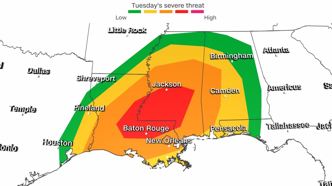
The storms will continue into Tuesday with even the possibility of a third round into Houston and eastern Texas on Tuesday morning, but our attention will shift eastward to Louisiana, Mississippi and Alabama throughout the day.
The worst of it will be centered in Louisiana and Mississippi, where a moderate risk, Level 4 of 5, includes Baton Rouge in Louisiana and Jackson in Mississippi.

“The risk for tomorrow is going to be more so during the daytime, which is a good thing in terms of people being more awake and alert,” Joanne Culin, of the NWS office in Jackson told CNN. “Unfortunately, we will tap into more of that daytime instability and fuel for thunderstorms.”
Just to the south of the bull’s-eye is New Orleans, which is within the enhanced risk, Level 3 of 5.
“Strong damaging winds,” are possible, said Tim Erickson of the NWS office in New Orleans. “Tornadoes will not be out of the question at all,” he added.
This area just north of New Orleans is where scientists are starting to deploy mobile radars, lightning mapping arrays and dozens of more instruments in a joint research project called PERiLS.
“Our target area is east-central Mississippi and west-central Alabama,” Tony Lyza, coordinator for NOAA’s involvement in PERiLS, told CNN.
Scientists say ‘never let your guard down’ in the Southeast
“You never let your guard down in the Southeast,” Christopher Weiss, professor of atmospheric science at Texas Tech tells CNN.
“It’s not just that they have tornadoes. But there are other factors - you can’t see them very well because of the hills and the trees.”
Jennifer and I have both gone out in the field with Weiss as he lays out the instruments called sticknets in front of an approaching storm.
They look like yellow tripods with devices on top that spin with the wind.

He was to lay out 16 instruments on Monday to start capturing wind and pressure data. Then Tuesday, they will monitor the data and as specific storms start to build, and he will deploy eight more in the path of the potential tornadic storm, usually within an area expecting a tornado warning.
“About an hour or so before the line arrives, we’ll put out our remaining eight probes, ahead of the line,” he explained. “So, it’s going to be dangerous.”
They drive quickly along a highway stopping at a good open spot. All doors swing open as his team gets out of the truck, grabbing a sticknet out of the trailer, running it out, unfolding it. One team member running with a hammer starts staking it into the ground. Another grabs and attaches the instruments and transmitter. Then, they run back to the truck.
As Jenn and I ran with them years ago, you can feel your heart racing as you pull your seat belt across your chest.
Then they race on to another location down the road, trying to deploy all eight.
“We need to be very careful, of course, about the storm that’s approaching, the tornado threat, of course, but also the lightning,” he added.
Tomorrow, he won’t be the only scientist in the field. A group of them from nine universities, three divisions of NOAA and the NSF are coming together Tuesday to get a better understanding of dangerous tornadic storms.
They can come with little warning
Look, we as meteorologists cringe anytime we hear someone interviewed after a tornado say these words: “It came without warning.”
The National Weather Service does an incredible job issuing warnings ahead of time. Not to mention days out, they begin telling people the likelihood of severe storms.
The stronger, more intense tornadoes typically happen from supercells, forming ahead of the main line of storms. They are easy to depict on radar and in a sense, are easier to give people warning on.
Know the difference between a tornado watch and a warning
But the group is studying tornadoes that can form within a line of storms.
“Tornadoes can spin up, and they tend to spin up with very little warning, sometimes even a short enough timespan that it gets in between the radar scans for the weather service,” Weiss pointed out.
“So that’s what we’re going to be focused on here is trying to try to learn more about how tornadoes are spawned from these linear storms, especially.”
“A lot of these tornadoes tend to happen at night, of course. It’s part of what makes this part of the country so appealing for this type of project because there are so many different ways that the storms can affect people out there.”
Nocturnal and rain-wrapped tornadoes
Both Monday night and Tuesday night, there will be a risk of nocturnal tornadoes, which is an incredibly dangerous scenario.
People can be caught off guard when the alerts wake them up in the middle of the night.
“People, you know of course sleeping, need a way to wake up whenever your alarm goes off for severe weather,” Erickson said.
He thinks there will be a line somewhere around New Orleans, which will be a threat there before or around midnight, and possibly even into the morning hours.
It’s not just the dark that could keep you from seeing the tornado coming. The air is so moist in the South, rain often wraps around tornadoes, and it can be hard to see them.
Heavy rainfall will make it extremely difficult to observe tornadoes as tornadoes will potentially become rain-wrapped fairly quickly, the Dallas NWS said.
The WPC has also issued a moderate risk, Level 3 of 4, for extreme rainfall for many of the same areas that could see tornadoes today and tomorrow.
It means, beyond rain-wrapped tornadoes, there will be the threat of flash flooding from Texas to Alabama. Flood watches have been issued along the Gulf Coast states from Texas to Mississippi on Monday, and they could expand into Alabama later today.
The flood threat will be highest where storms train over the same areas “and drop a tremendous amount of rainfall and locally up to six inches or more is certainly not out of the question,” the NWS office in Shreveport said Monday.
CNN meteorologists Taylor Ward and Jennifer Gray contributed to this article.


