The next couple of months could be a wild ride for many if NOAA’s Atlantic hurricane mid-season update proves true.
The National Oceanic and Atmospheric Administration (NOAA)has doubled down on its initial seasonal forecast issued in May by announcing Wednesday that the season will continue to be above-average. Forecaster’s confidence has increased and the probability of an above-normal season has risen from 60% to 65%, leaving only a 10% probability of a below-normal season and a 25% probability of a normal season.

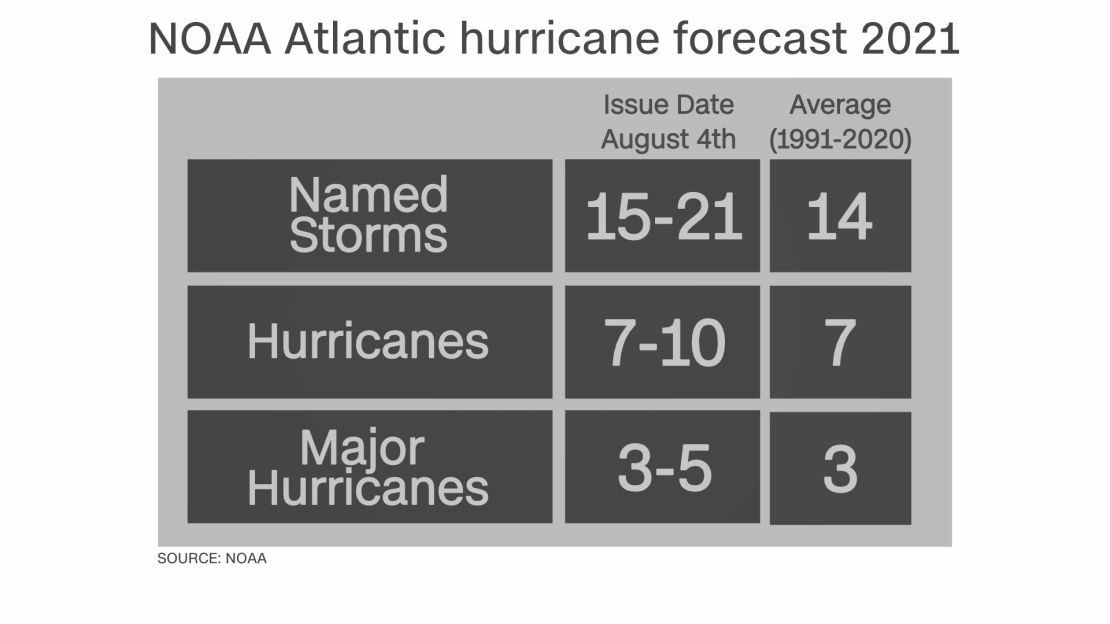
The latest projections call for 15-21 named storms (winds of 39 mph or greater), while the initial seasonal outlook forecast was 13-20. This includes the five named storms so far this season.
NOAA’s Climate Prediction Center also predicts seven to 10 hurricanes (winds of 74 mph or greater), while the initial forecast called for six to 10. Of those predicted hurricanes, three to five are forecast to be major (Category 3, 4, or 5 with winds 111 mph or greater), which remains unchanged from their previous outlook.
“There is a 15% chance that the season could end with higher or lower averages than what they are forecasting,” says Matthew Rosencrans, lead seasonal hurricane forecaster at the Climate Prediction Center (CPC).
The tropics are already starting to wake up after a recent lull in activity. Currently, there are two disturbances that the National Hurricane Center is monitoring.
La Niña could come back to haunt us
Certain meteorological conditions factor into the above-average Atlantic hurricane season that likely remains, according to NOAA scientists.The Atlantic hurricane season runs between June 1 to November 30, with peak months being August, September and October.
“A mix of competing oceanic and atmospheric conditions generally favor above-average activity for the remainder of the Atlantic hurricane season, including the potential return of La Niña in the months ahead,” Rosencrans said.
After La Niña’s brief hiatus this past spring, the CPC has issued a La Niña watch, which means conditions are favorable for the phenomenon to redevelop within the next six months. If it corresponds with the peak of the hurricane season, tropical activity can ramp up quickly.
It’s hard to imagine that cooler than average ocean temperatures across the eastern Pacific can play a role in tropical development across the Atlantic, but the two are closely linked.
During a La Niña season, shifting weather patterns associated with the cooler eastern Pacific waters has been known to weaken vertical wind shear across the Atlantic. The absence of this wind shear between the ocean surface and the upper levels of the atmosphere, coupled with other meteorological phenomena, are expected to make the ideal breading ground for hurricanes.
Scientists with NOAA pointed to an enhanced west Africa monsoon that’s ejecting thunderstorms into the Atlantic Ocean that’s primed for development. These parameters all favor an active season.
CNN meteorologist Taylor Ward says, “When the West African monsoon is strong, these easterly waves tend to be more robust and the upper level winds are more favorable for these waves to spin and produce tropical storms.”
Not as hyperactive as 2020 hurricane season
Even though the next few months will be active, forecasters are not anticipating this season to be as supercharged as 2020, where the named storms outlasted the standard alphabet and extra names were used for only the second time in history.
This is likely because Atlantic sea surface temperatures are not expected to be as warm this year compared to the record-breaking season.
Colorado State University’s Tropical Weather and Climate Research Center, a highly respected hurricane forecast group, will issue its updated seasonal tropical forecast Thursday.
One thing every meteorologist will say is that it only takes one storm to devastate a community.
That is why it is imperative that you and your family are prepared for the months ahead by reviewing your evacuation guide and having your hurricane preparedness kit ready.


