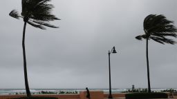
Forecasters are now calling for an increased chance of La Niña this autumn, which could enhance an already overly active hurricane season.
The National Oceanic and Atmospheric Administration (NOAA), issued a La Niña Watch in July. Now, the agency has issued an update further showing their confidence that La Niña could form this autumn.
“The La Niña Watch that was issued back in July has now increased to 60% for this fall,” says Haley Brink, CNN meteorologist. “When a La Niña Watch is issued that means that conditions are favorable for development within the next six months. An advisory can then be issued once La Niña conditions are observed.”

What exactly is La Niña?
La Niña is essentially the “cool phase” of the El Niño-Southern Oscillation (ENSO) climate pattern, which is a naturally occurring phenomenon that involves fluctuating ocean temperatures in the Pacific.
La Niña is the opposite of El Niño, which is the warm phase of the cycle.

In a typical El Niño phase, much of the Pacific Ocean is characterized by warmer waters, whereas La Niña features a cooling of those same Pacific waters. More importantly, especially in the case of hurricanes, La Niña weakens high atmospheric winds, which allows warm air pockets to grow vertically and develop into hurricanes.
The opposite occurs during an El Niño, which causes cool, dry, and atmospherically unstable conditions in the Atlantic.
La Niña and the 2020 Atlantic hurricane season
So, now that we know La Niña does not inhibit tropical development, what does this mean for our already record-breaking hurricane season?
“This is troubling because we have already had a very active hurricane season across the Atlantic with 11 named storms and we are still one month away from peak hurricane season,” cautions Brink. “We typically do not have 11 named storms until November 23, across the Atlantic Ocean.”
“Come peak hurricane season in September, the prevailing tropical storm tracks increase across the Gulf of Mexico and the Caribbean; in addition to storm formation originating off the coast of Africa.”
There are a lot of comparisons out there to the record-breaking 2005 Atlantic hurricane season because not only is this year’s hurricane season currently on pace to match the number of named storms, it also happened to be a year where La Niña developed in the autumn.

What does La Niña mean for the continental US?
La Niña doesn’t just affect oceans, it also affects the weather on land too. During a La Niña winter, warmer and drier conditions usually arise from South Carolina to Southern California. This does not bode well for areas of the desert Southwest this year, since many areas are already dealing with record heat and lower than average rainfall.
Santa Fe, New Mexico, Phoenix and Flagstaff, Arizona, haven’t recorded rain since the end of July. There’s also Los Angeles and San Diego, California, which haven’t reported any since May and June, respectively. It’s been even longer for places like Palm Springs, California, and Las Vegas and Yuma, Arizona, that haven’t recorded rain since April.
For a city like Tucson, they are on pace to finish in the top 10 driest monsoon years, and that is without factoring in a La Niña in the fall and winter.


