Photos: Deadly tornado hits Oklahoma
Photos: Deadly tornado hits Oklahoma
Deadly tornado hits Oklahoma City area – Left to right, Jaqi Castro, Angelica Morris-Smith and Cetoria Petties walk through a tornado ravaged neighborhood handing out supplies to residents and fellow volunteers on May 27.
Photos: Deadly tornado hits Oklahoma
Deadly tornado hits Oklahoma City area – Residents gather in the First Baptist Church for the Oklahoma Strong memorial service on Sunday, May 26, to honor victims of the recent deadly tornado in Moore, Oklahoma.
Photos: Deadly tornado hits Oklahoma
Deadly tornado hits Oklahoma City area – Preschooler Keltin Marazzi, front center, stands on stage with other school children during the memorial service.
Photos: Deadly tornado hits Oklahoma
Deadly tornado hits Oklahoma City area – Oklahoma Gov. Mary Fallin addresses the audience on May 26.
Photos: Deadly tornado hits Oklahoma
Deadly tornado hits Oklahoma City area – Tornado victims Christa and Russell Smith hug their children, Evan and Justin Smith, as the service takes place.
Photos: Deadly tornado hits Oklahoma
Deadly tornado hits Oklahoma City area – Plaza Towers Elementary School teacher Jennifer Doan is comforted by her fiance, Nyle Rogers, on May 26.
Photos: Deadly tornado hits Oklahoma
Deadly tornado hits Oklahoma City area – President Barack Obama is greeted as he tours the tornado-ravaged area near Moore, Oklahoma, on Sunday, May 26.
Photos: Deadly tornado hits Oklahoma
Deadly tornado hits Oklahoma City area – Volunteers bow their heads in reverence on Saturday, May 25, in front of a memorial at the Plaza Towers Elementary School where seven children died during the devastating tornado, in Moore, Oklahoma, on May 20.
Photos: Deadly tornado hits Oklahoma
Deadly tornado hits Oklahoma City area – Mike Hitch prepares to pull a classic Corvette from under the debris of a home destroyed by Monday's tornado on May 25.
Photos: Deadly tornado hits Oklahoma
Deadly tornado hits Oklahoma City area – Mike Hitch loads a salvaged Corvette pulled from the rubble onto a tow truck in Moore on May 25.
Photos: Deadly tornado hits Oklahoma
Deadly tornado hits Oklahoma City area – Eunice Lassiter sits in the driveway of a friend's tornado-damaged home on May 25 in Moore.
Photos: Deadly tornado hits Oklahoma
Deadly tornado hits Oklahoma City area – A volunteer signs a cross on May 25 at a makeshift memorial outside of the destroyed Plaza Towers Elementary School where seven children were killed in Monday's tornado in Moore.
Photos: Deadly tornado hits Oklahoma
Deadly tornado hits Oklahoma City area – Volunteers unload donated items for tornado victims at the Yellow Rose Theater on May 25 in Moore.
Photos: Deadly tornado hits Oklahoma
Deadly tornado hits Oklahoma City area – Volunteer Brittany Pendergraft organizes donated tornado relief items inside the Yellow Rose Theater on May 25 in Moore.
Photos: Deadly tornado hits Oklahoma
Deadly tornado hits Oklahoma City area – Eddie Jones of the Christian Life Center in Rolla, Missouri, cooks for residents and volunteers helping with tornado relief on May 25 in Moore.
Photos: Deadly tornado hits Oklahoma
Deadly tornado hits Oklahoma City area – Carol Kawaykla holds a picture of her mother she found in the rubble of her tornado-devastated home in Moore, Oklahoma, on May 24.
Photos: Deadly tornado hits Oklahoma
Deadly tornado hits Oklahoma City area – The sun sets over debris from houses littering the ground in Moore, Oklahoma, on Thursday, May 23, three days after the town was damaged by a tornado.
Photos: Deadly tornado hits Oklahoma
Deadly tornado hits Oklahoma City area – Debris is scattered across a driveway on May 23. Severe thunderstorms barreled through this Oklahoma City suburb at dawn Thursday, complicating cleanup efforts.
Photos: Deadly tornado hits Oklahoma
Deadly tornado hits Oklahoma City area – Lightning strikes during a thunderstorm as people search for items that can be saved from their devastated home on May 23.
Photos: Deadly tornado hits Oklahoma
Deadly tornado hits Oklahoma City area – A devastated neighborhood is seen on May 23 in Moore.
Photos: Deadly tornado hits Oklahoma
Deadly tornado hits Oklahoma City area – A woman searches for belongings at a home on May 22 in Moore.
Photos: Deadly tornado hits Oklahoma
Deadly tornado hits Oklahoma City area – Michael Pritz swings a golf club while taking a break from helping his friend to salvage belongings on May 22.
Photos: Deadly tornado hits Oklahoma
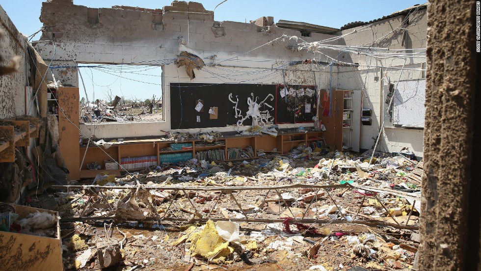
Deadly tornado hits Oklahoma City area – Debris litters what remains of a classroom at Plaza Towers Elementary School on May 22. Seven children died at the school in Monday's tornado.
Photos: Deadly tornado hits Oklahoma
Deadly tornado hits Oklahoma City area – A makeshift shelter stands next to a home destroyed by the tornado on May 22.
Photos: Deadly tornado hits Oklahoma
Deadly tornado hits Oklahoma City area – Casey Angle walks on the bunk bed she shared with her sister Sydney, who was among the students killed at Plaza Towers Elementary School during the tornado.
Photos: Deadly tornado hits Oklahoma
Deadly tornado hits Oklahoma City area – Tara McDonald shows some items salvaged from her home on May 22.
Photos: Deadly tornado hits Oklahoma
Deadly tornado hits Oklahoma City area – A swing set sits warped at Plaza Towers Elementary School on May 22.
Photos: Deadly tornado hits Oklahoma
Deadly tornado hits Oklahoma City area – Plaza Towers Elementary School students Monica Boyd and Lavontey Rodriguez sit at the parking lot of their tornado devastated school.
Photos: Deadly tornado hits Oklahoma
Deadly tornado hits Oklahoma City area – Travis French and his wife, Amy, of Capitol Hill Baptist Church hand out fresh fruit, water and hygiene packs to Thomas and Kelcy Trowbridge.
Photos: Deadly tornado hits Oklahoma
Deadly tornado hits Oklahoma City area – Teachers from Fairview Elementary School help clean up former school counselor Kay Taylor's home in south Oklahoma City on May 22, two days after an extremely powerful tornado tore through Moore, Oklahoma.
Photos: Deadly tornado hits Oklahoma
Deadly tornado hits Oklahoma City area – Jake English, 12, cleans up retired school counselor Kay Taylor's home on May 22 in south Oklahoma City, just west of Moore. The storm was part of a tornado outbreak that began in the Midwest and Plains on Sunday, May 19.
Photos: Deadly tornado hits Oklahoma
Deadly tornado hits Oklahoma City area – A man talks on his cell phone in front of a destroyed house on May 22.
Photos: Deadly tornado hits Oklahoma
Deadly tornado hits Oklahoma City area – A man looks through a pile of clothing at a roadside relief camp on May 22 in Moore.
Photos: Deadly tornado hits Oklahoma
Deadly tornado hits Oklahoma City area – Volunteers form a chain to retrieve clothing and other household items on May 22.
Photos: Deadly tornado hits Oklahoma
Deadly tornado hits Oklahoma City area – Jon Booth moves a piece of debris from his mother's destroyed home across the street from Plaza Towers Elementary School on May 22.
Photos: Deadly tornado hits Oklahoma
Deadly tornado hits Oklahoma City area – Matt Johnson salvages items from his grandparents' home on Tuesday, May 21.
Photos: Deadly tornado hits Oklahoma
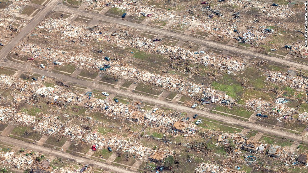
Deadly tornado hits Oklahoma City area – An aerial view of the destruction on May 21.
Photos: Deadly tornado hits Oklahoma
Deadly tornado hits Oklahoma City area – The storm, which touched down near Newcastle, Oklahoma, spanned 1.3 miles. Some areas along the path were completely flattened.
Photos: Deadly tornado hits Oklahoma
Deadly tornado hits Oklahoma City area – Two men fold an American flag found in the debris of a house on May 21 in Moore.
Photos: Deadly tornado hits Oklahoma
Deadly tornado hits Oklahoma City area – A young girl stands among the rubble outside Briarwood Elementary School on May 21.
Photos: Deadly tornado hits Oklahoma
Deadly tornado hits Oklahoma City area – A doll covered in dirt is among the rubble scattered throughout a neighborhood in Moore on May 21.
Photos: Deadly tornado hits Oklahoma
Deadly tornado hits Oklahoma City area – Bonnie Lolofie, left, and Ashley Do carry belongings from their apartment, which has no power, on May 21.
Photos: Deadly tornado hits Oklahoma
Deadly tornado hits Oklahoma City area – Residents salvage belongings from their demolished homes in Moore on May 21.
Photos: Deadly tornado hits Oklahoma
Deadly tornado hits Oklahoma City area – Kelli Kannady weeps after finding a box of photographs of her late husband in the rubble near where her home once stood in Moore on May 21.
Photos: Deadly tornado hits Oklahoma
Deadly tornado hits Oklahoma City area – Tufts of pink insulation hang from the rafters of a store in Moore on May 21 that was destroyed in the storm.
Photos: Deadly tornado hits Oklahoma
Deadly tornado hits Oklahoma City area – Natalie Johnson searches through her mother's destroyed car outside Briarwood Elementary School in Moore on May 21.
Photos: Deadly tornado hits Oklahoma
Deadly tornado hits Oklahoma City area – Rescuers dig out a house in Moore on May 21.
Photos: Deadly tornado hits Oklahoma
Deadly tornado hits Oklahoma City area – June Simson embraces her cat Sammi after she found him standing among the rubble of her destroyed home in Moore on May 21.
Photos: Deadly tornado hits Oklahoma
Deadly tornado hits Oklahoma City area – A man stands on the roof of a destroyed home in Moore on May 21.
Photos: Deadly tornado hits Oklahoma
Deadly tornado hits Oklahoma City area – A man helps move a resident's belongings from a destroyed home on May 21 in Moore.
Photos: Deadly tornado hits Oklahoma
Deadly tornado hits Oklahoma City area – Air Force Airman First Class Justin Acord sifts through the rubble of his father-in-law's home in Moore on May 21.
Photos: Deadly tornado hits Oklahoma
Deadly tornado hits Oklahoma City area – People recover belongings from the rubble of a home in Moore.
Photos: Deadly tornado hits Oklahoma
Deadly tornado hits Oklahoma City area – People sort through a leveled home in Moore on May 21.
Photos: Deadly tornado hits Oklahoma
Deadly tornado hits Oklahoma City area – Debris lies among headstones in the Moore Cemetery on May 21.
Photos: Deadly tornado hits Oklahoma
Deadly tornado hits Oklahoma City area – Workers clean up the Warren movie theater in Moore on May 21.
Photos: Deadly tornado hits Oklahoma
Deadly tornado hits Oklahoma City area – Oklahoma City Mayor Mick Cornett surveys damage in Moore on May 21.
Photos: Deadly tornado hits Oklahoma
Deadly tornado hits Oklahoma City area – Piles of debris lie around the north side of Plaza Towers Elementary School in Moore on May 21.
Photos: Deadly tornado hits Oklahoma
Deadly tornado hits Oklahoma City area – As dawn breaks, storm clouds roll in over a devastated neighborhood in Moore on May 21.
Photos: Deadly tornado hits Oklahoma
Deadly tornado hits Oklahoma City area – Members of the Oklahoma National Guard look for survivors in rubble in Moore on May 21.
Photos: Deadly tornado hits Oklahoma
Deadly tornado hits Oklahoma City area – A National Guardsman assists in the search for victims on May 21.
Photos: Deadly tornado hits Oklahoma
Deadly tornado hits Oklahoma City area – A rescue worker leads a horse from the wreckage of a day care center and barns on Monday, May 20, in Moore.
Photos: Deadly tornado hits Oklahoma
Deadly tornado hits Oklahoma City area – Men tie an American flag on debris in a neighborhood off Telephone Road in Moore on May 20.
Photos: Deadly tornado hits Oklahoma
Deadly tornado hits Oklahoma City area – Children wait for their parents to arrive at Briarwood Elementary School in south Oklahoma City on May 20.
Photos: Deadly tornado hits Oklahoma
Deadly tornado hits Oklahoma City area – Teachers carry children away from Briarwood Elementary School on May 20.
Photos: Deadly tornado hits Oklahoma
Photos: Deadly tornado hits Oklahoma
Deadly tornado hits Oklahoma City area – A fire official drives through the rubble of Moore Medical Center on May 20.
Photos: Deadly tornado hits Oklahoma
Deadly tornado hits Oklahoma City area – Abby Madi, left, and Peterson Zatterlee comfort Zatterlee's dog, Rippy, on Monday, May 20, in Moore.
Photos: Deadly tornado hits Oklahoma
Deadly tornado hits Oklahoma City area – A woman is treated for her injuries on May 20 at a triage area set up for the wounded.
Photos: Deadly tornado hits Oklahoma
Deadly tornado hits Oklahoma City area – Two girls stand in rubble in Moore.
Photos: Deadly tornado hits Oklahoma
Deadly tornado hits Oklahoma City area – Rescue workers help free one of more than a dozen people who were trapped at a medical center in Moore on May 20.
Photos: Deadly tornado hits Oklahoma
Deadly tornado hits Oklahoma City area – Oklahoma City firefighters check on Gene Tripp on May 20 as he sits in his rocking chair where his home once stood.
Photos: Deadly tornado hits Oklahoma
Deadly tornado hits Oklahoma City area – A nurse helps an older man who suffered a head injury on May 20 in Moore.
Photos: Deadly tornado hits Oklahoma
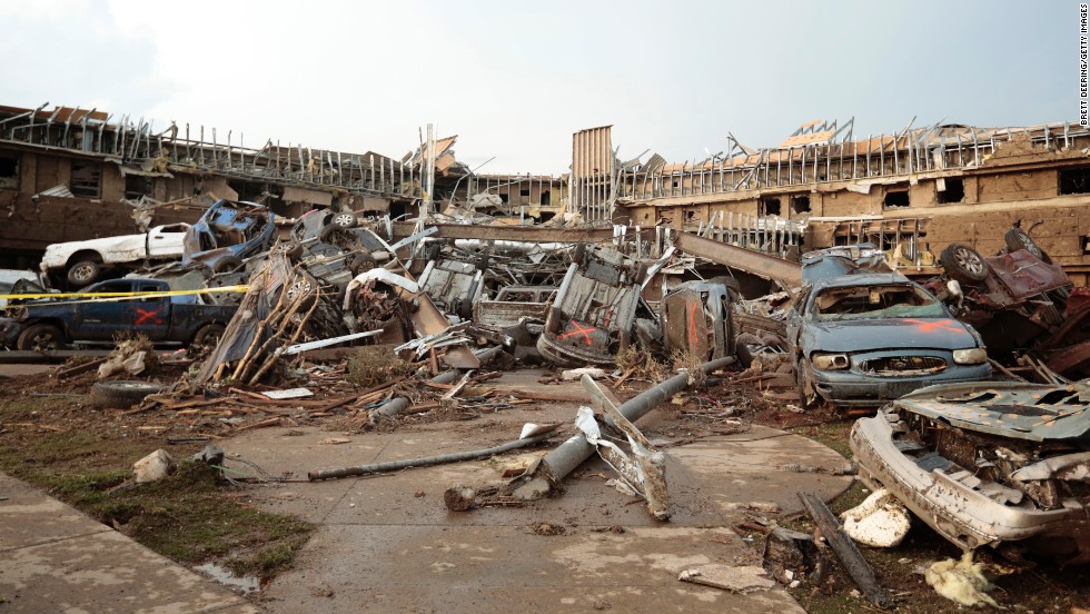
Deadly tornado hits Oklahoma City area – Cars marked with an orange X, meaning they have been checked for occupants, are piled up in front of the entrance to the damaged Moore Medical Center on May 20.
Photos: Deadly tornado hits Oklahoma
Photos: Deadly tornado hits Oklahoma
Deadly tornado hits Oklahoma City area – People look through the wreckage of their neighborhood after a tornado struck Moore, Oklahoma, on May 20.
Photos: Deadly tornado hits Oklahoma
Deadly tornado hits Oklahoma City area – Dana Ulepich searches inside a room left standing at the back of her destroyed house in Moore on May 20.
Photos: Deadly tornado hits Oklahoma
Deadly tornado hits Oklahoma City area – Residents look through the debris in Moore on May 20.
Photos: Deadly tornado hits Oklahoma
Deadly tornado hits Oklahoma City area – A man looks through the remains of a home after the massive tornado struck Moore on May 20.
Photos: Deadly tornado hits Oklahoma
Deadly tornado hits Oklahoma City area – A woman is transported on a stretcher after she was rescued from the damaged medical center in Moore on May 20.
Photos: Deadly tornado hits Oklahoma
Deadly tornado hits Oklahoma City area – A woman walks through debris in Moore on May 20.
Photos: Deadly tornado hits Oklahoma
Deadly tornado hits Oklahoma City area – A man is taken away from the IMAX Theater in Moore that was used as a triage center on May 20.
Photos: Deadly tornado hits Oklahoma
Deadly tornado hits Oklahoma City area – A girl wraps herself in a blanket near the Moore Hospital on May 20.
Photos: Deadly tornado hits Oklahoma
Deadly tornado hits Oklahoma City area – A nurse walks by the destruction at a Moore hospital on May 20.
Photos: Deadly tornado hits Oklahoma
Deadly tornado hits Oklahoma City area – Destroyed cars scatter the landscape in Moore, Oklahoma, where hundreds of homes and buildings were put to ruin on May 20.
Photos: Deadly tornado hits Oklahoma
Deadly tornado hits Oklahoma City area – A woman with an arm injury is helped on May 20 in Moore.
Photos: Deadly tornado hits Oklahoma
Deadly tornado hits Oklahoma City area – Extensive damage from the tornado destroyed cars and demolished structures in Moore on May 20.
Photos: Deadly tornado hits Oklahoma
Deadly tornado hits Oklahoma City area – Onlookers stop to view a portion of the destruction left behind on May 20 in Moore.
Photos: Deadly tornado hits Oklahoma
Deadly tornado hits Oklahoma City area – Overturned cars are among the rubble from the tornado that hit Moore on May 20.
Photos: Deadly tornado hits Oklahoma
Deadly tornado hits Oklahoma City area – A woman is comforted after the May 20 tornado in Moore.
Photos: Deadly tornado hits Oklahoma
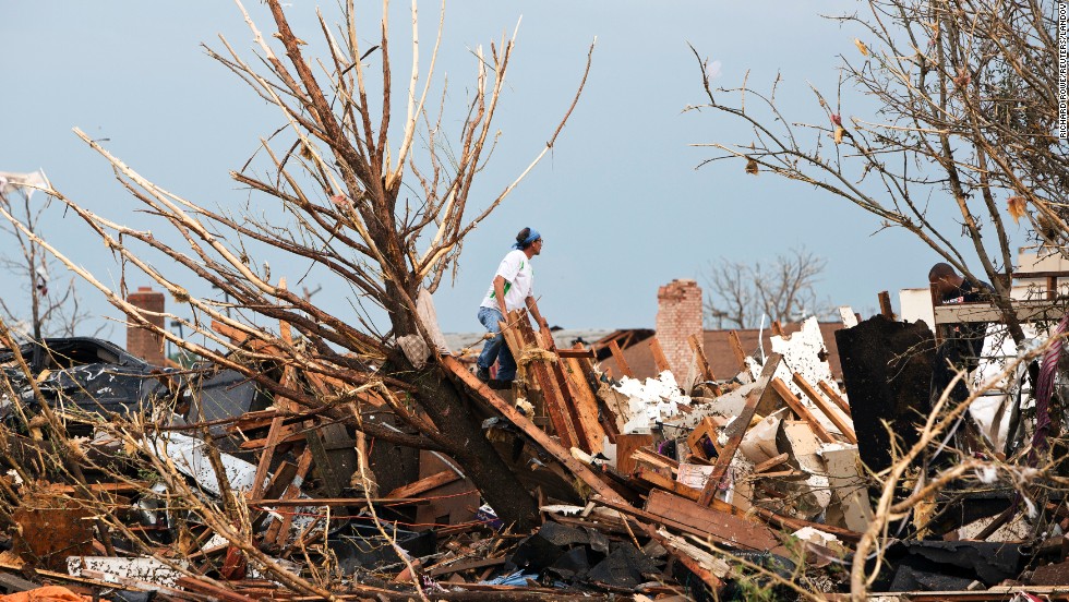
Deadly tornado hits Oklahoma City area – A shredded tree stands amid debris in the aftermath of the storm in Moore on May 20.
Photos: Deadly tornado hits Oklahoma
Deadly tornado hits Oklahoma City area – A shopping center parking lot is covered with debris and damaged cars on May 20.
Photos: Deadly tornado hits Oklahoma
Deadly tornado hits Oklahoma City area – Law enforcement officers block a roadway in Moore where there was extensive damage from the tornado.
Photos: Deadly tornado hits Oklahoma


