July 5, 2024, Tropical Storm Beryl news | CNN

July 5, 2024, Tropical Storm Beryl news

still_20765060_3245615.8989999997_still.jpg
‘Dangerous day’: Beryl takes aim at Texas
01:43 - Source: CNN

What we covered here

  • Track the storm: Beryl is now a tropical storm and is unloading strong winds, torrential rainfall and dangerous storm surge over a significant portion of Mexico’s Yucatan Peninsula after hammering several Caribbean islands. The storm has killed at least nine people. Stay updated on its path here.
  • Forecast: The storm will continue to weaken and emerge in the Gulf of Mexico Friday evening. It’s expected to strengthen again ahead of its final landfall in South Texas as a hurricane late this weekend into early next week.
  • Historic storm: Beryl was previously the earliest Category 5 storm on record in the Atlantic. It was also the strongest storm to impact Jamaica in over 15 years.
  • Rapid intensification: The abnormally warm ocean waters that facilitated Beryl’s intensification show that this hurricane season will be far from normal due to global warming caused by fossil fuel pollution.
  • If you are in an area of low connectivity, get the latest CNN updates here.
25 Posts

Our live coverage for the day has ended. Track Beryl’s path here and read through the posts below to catch up on the forecast.

Hurricane and storm surge watches issued for Texas and Mexico's Gulf Coast

Tropical Storm Beryl will emerge into the Gulf of Mexico in the next few hours, strengthen as it tracks toward the Texas-Mexico border this weekend, and bring impacts to the US beginning late Sunday.

The National Hurricane Center has issued hurricane and storm surge watches for the Texas coast from the mouth of the Rio Grande northward to Sargent, including Corpus Christi. A hurricane watch is also in effect for the northeastern coast of Mexico, from Barra el Mezquital to the mouth of the Rio Grande.

Tropical storm conditions will begin to be felt along the western Gulf Coast on Sunday, with hurricane conditions expected later in the day. Storm surge up to 5 feet is also forecast for southern portions of the Texas Coast.

“Heavy rainfall of 5 to 10 inches with localized amounts of 15 inches is expected across portions of the Texas Gulf Coast and eastern Texas beginning late Sunday through the middle of next week,” the center said, adding, “This rainfall is expected to produce areas of flash and urban flooding.” 

Rip currents will cause life-threatening beach conditions through the weekend across much of the Gulf Coast.

"Everyone along the coast should be paying attention": Texas officials urge residents to prepare for Beryl

Texas officials are warning about heavy rain and flooding, urging residents to prepare before Beryl is expected to hit coastal areas starting later this weekend.

Texas Lt. Gov. Dan Patrick, who is overseeing the response operations while Gov. Greg Abbott is out of the country, said the storm is still strong as it moves over a significant portion of Mexico’s Yucatan Peninsula.

“Everyone along the coast should be paying attention to this storm,” Patrick said during a briefing on Friday. He said the state is likely to start seeing the impacts of Beryl starting Sunday into Monday.

After the storm moves into the Gulf of Mexico this weekend, Patrick said officials will have more information about where exactly it is heading. Still, he asked all residents to be prepared, especially with people gathering around coastal areas for the Fourth of July holiday weekend.

Chief of the Texas Division of Emergency Management W. Nim Kidd gave some tips for residents to prepare for the storm:

  • Make sure you have gas in your car
  • Stock up on enough food and water
  • Take care of pets and check on family members

“We need a prepared community, not a panicked community,” Kidd said, adding that his department is making sure state resources are available to support local governments.

Beryl is now a tropical storm

Beryl has lost considerable strength over the Yucatán Peninsula and is now a tropical storm unloading heavy rain and gusty winds. The storm will also continue to produce storm surge on the peninsula’s western shores.

Beryl has sustained winds of 70 mph and is tracking west-northwest at 15 mph. The tropical storm is located approximately 65 miles from Progreso, Mexico, with tropical storm-force winds extending 105 miles from its center.

Being over land will continue to weaken Beryl, but the cyclone will emerge back over water later today in the Gulf of Mexico where it will regain strength this weekend. The storm is forecast to become a hurricane again before ramming South Texas late this weekend into early next week.

Watch Beryl make a 2,000 mile journey in about 30 seconds

New imagery shows powerful Hurricane Beryl’s 2,000 mile lifecycle from the Atlantic through the Caribbean and into its Mexico landfall this morning. 

This imagery from the University of Wisconsin-Madison’s Cooperative Institute for Meteorological Satellite Studies uses a blend of components to track a storm’s center, or eye.

The eye is created by a cluster of incredibly strong winds called the eyewall. Winds within the eyewall spin so fast they create a vacuum of calm weather in the center of a storm. 

What this imagery shows is not something that could be seen from space with the naked eye or captured with weather radar, but it helps researchers see the health of the storm through how the eye changes with time. 

In the loop, Beryl’s eye gets quite large and circular as it crosses through the Grenadines and eastern Caribbean Sea. That’s one sign of a very powerful storm. Beryl became the earliest Category 5 hurricane on record shortly after moving through the Grenadines. 

Beryl also maintains a very strong, circular eye in the loop as it skims Jamaica as a Category 4 hurricane. 

While Beryl approaches Mexico’s Yucatán Peninsula, its eye gets smaller and more elliptical rather than circular – a sign the storm was starting to weaken. Beryl did make landfall as a Category 2 hurricane but quickly lost strength over land, reaching Category 1 status late Monday morning. 

"Time to prepare" for potential impacts from Beryl, Texas weather office says

The National Weather Service in Corpus Christi is warning residents that “now would be the time to prepare” for Hurricane Beryl as its track forecast is trending farther north along the Texas coast.

The National Weather Service in Houston is also asking people in the area to stay vigilant. “At this time, the main impacts for SE TX will remain increased rainfall (Mon/Tues) and the potential for tropical storm force winds (34kts) as early as Sun morning. Stay tuned and stay informed,” the weather service posted on X.

Be ready: The Texas Division of Emergency Management is encouraging Texans to make a plan and has set up a resources page for Beryl.

Use this checklist to help with preparing for power outages, heavy rain and flooding that could accompany the hurricane. Before the storm arrives, federal and emergency agencies suggest topping off gas tanks, filling up the bathtub with water and finding local shelters. They advise keeping a first-aid kit, extra batteries and canned foods on hand as well.

Print out a PDF of the checklist to stay organized.

Beryl's track shifts north along the South Texas coast. Here's what you should know

Hurricane and tropical storm watches will likely be issued later today for parts of Texas and northeastern Mexico as Beryl eyes a third landfall, according to the NHC.

Beryl’s track forecast continues to trend farther north along the Texas coast and could shift further in the coming days. Damaging winds, life-threatening storm surge, heavy rainfall and dangerous flooding will all possible in parts of Texas and northeastern Mexico regardless, according to the NHC.  

Beryl may also get stronger than the Category 1 hurricane currently forecast at landfall the longer it remains over the Gulf. Strengthening is expected up until landfall in South Texas early Monday morning, but heavy rain will likely begin Sunday in parts of Texas and northeastern Mexico.

Beryl is a Category 1 hurricane as it moves through the Yucatán Peninsula

Beryl has lost additional strength and is now a Category 1 hurricane as it tracks over land and away from its strength-sustaining warm ocean water. It continues to produce strong winds, heavy rain and dangerous storm surge.

Beryl has sustained winds of 85 mph and is tracking west-northwest at 16 mph, according to the National Hurricane Center. The hurricane is located approximately 100 miles east-southeast of Progreso, Mexico. Its hurricane-force winds extend 25 miles from its center and tropical storm-force winds reach 105 miles.

Being over land will continue to weaken Beryl, but the cyclone will emerge back over water later today in the Gulf of Mexico, likely as a tropical storm. Once in the Gulf, Beryl is expected to regain strength this weekend and become a hurricane again before taking aim at South Texas.

Hurricane Beryl moves over the Yucatán Peninsula late Friday morning.

Beryl worsened by climate change, study finds

Hurricane Beryl’s blow to Jamaica was worsened by climate change, a new rapid attribution analysis from ClimaMeter found.

Modern storms like Beryl tracking close to Jamaica are capable of unloading 30% more rain and 10% stronger winds compared to the similar storms from 1979 to 2001 because of human-caused climate change, the study found.

The storm drenched Kingston, Jamaica’s capital, in more than double the amount of rain it typically receives for the whole month of July in just 24 hours Wednesday. The city also endured 12 consecutive hours of tropical-storm force winds. The storm killed two people in the island nation.

“The increase in precipitation and wind speed of this type of event has been significantly intensified by human-driven climate change,” Tommaso Alberti, a researcher involved in the study said.

“This means that while we might see similar episodes with the same frequency, their intensity will be stronger, leading to catastrophic consequences for the vulnerable Caribbean Islands.”

Beryl became the earliest Category 5 hurricane in the Atlantic on record earlier this week.

Previous studies show that there will be more of the most intense tropical cyclones as the planet warms from fossil fuel pollution; more storms are also rapidly intensifying as ocean temperatures rise; and rainfall from tropical cyclones is also being supercharged by the warming planet.

CNN’s Brandon Miller, Mary Gilbert, Michael Rios and Jennifer Deaton contributed to this report

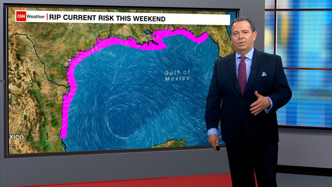
Beryl will generate a considerable rip current risk for the US Gulf Coast this weekend

Beryl will pose a danger to the US Gulf Coast as soon as it emerges into the Gulf of Mexico later today. The potent storm will churn up seas throughout the Gulf and ramp up the risk of life-threatening rip currents for hundreds of miles of US coastline this holiday weekend.

Fourth of July weekend is one of the most popular beach weekends of the year as people flock to the coasts to beat the summertime heat. 

The “development of dangerous rip currents” is possible as early as Friday evening, the National Weather Service in Mobile, Alabama, warned Friday morning. “Those visiting area beaches should familiarize themselves with the beach flag system and follow lifeguard instructions.”

The surf will be dangerous for all levels of swimmers this weekend where rip currents occur, according to the NWS. Rip currents can overwhelm even the strongest swimmers. They’re easy to spot from the shore but are tricky to see for anyone already in the water.

“Life-threatening beach conditions” are possible for much of the Gulf Coast, the National Hurricane Center warned Friday. Some pockets of the coast may have safe swimming conditions, but those may be few and far between.

At least 19 people have lost their lives in rip currents this year in the US or its territories, according to the National Weather Service. More than a third of these deaths occurred along the Gulf Coast.

Learn more about rip currents here.

9e5c2f94-db3a-4ac6-9f8c-00933b7365d3

Beryl now forecast to make landfall in South Texas

Beryl is now forecast to make landfall over South Padre Island, Texas, close to the Texas-Mexico border, as a Category 1 hurricane late Sunday night, according to the National Hurricane Center.

But Beryl’s exact landfall location, timing and intensity could shift in the coming days.

Beryl has defied forecasts calling for it to weaken considerably from typically storm-stopping upper level winds by tracking through a Caribbean Sea as warm as it should be in September.

So, forecasters first need to see exactly what the resilient cyclone is capable of in the Gulf of Mexico.

There’s a chance landfall could occur anywhere from northeastern Mexico to the Texas-Louisiana border, according to the NHC’s latest forecast cone. The forecast cone represents where the center of a cyclone is likely to track 60 to 70% of the time. 

If the current track verifies, Beryl will become the first US landfall storm of the 2024 Atlantic hurricane season.

Beryl weakens over Mexico but remains a Category 2 hurricane

Hurricane Beryl impacts Tulum, Mexico, on Friday.

Beryl remains a Category 2 hurricane, but its winds have weakened to 100 mph after making landfall with 110 mph winds earlier this morning, according to the National Hurricane Center.

Beryl is tracking west-northwest at 15 mph across the Yucatán Peninsula and is now located inland about 15 miles north-northwest of Tulum, Mexico.

The hurricane will continue to weaken now that it is cut off from the warm waters of the Caribbean Sea that fueled its impressive strength this week.

Category 2 hurricanes have sustained wind speeds of 96 to 110 mph.

Watch Beryl make landfall from space

Satellite imagery captured Beryl’s landfall Friday morning near Tulum, Mexico, as a strong Category 2 hurricane. This is Beryl’s second official landfall. The first occurred on Monday when Beryl roared over Carriacou in the Grenadines as a Category 4 hurricane.

Hurricane Beryl makes landfall in Mexico Friday morning.

Hurricane-force gusts slam Mexico as Beryl makes landfall

Winds are intensifying on the Mexico coast as Hurricane Beryl roars ashore.

A weather station near Playa del Carmen recently reported a wind gust of 81 mph, according to the National Hurricane Center. Winds are gusting between 40 and 50 mph father north in Cancún.

Damaging winds will spread inland over more of the peninsula this morning as Beryl tracks over the region.

Beryl makes landfall near popular tourist area of Mexico's Yucatán Peninsula

Hurricane Beryl made landfall near the popular tourist area of Tulum as a strong Category 2 hurricane with 110 mph winds. 

It’s only the third hurricane to make landfall on Mexico’s Yucatán Peninsula in July. The last was Category 4 Emily in 2005.

The storm is tracking across the peninsula at 15 mph and unloading destructive winds, storm surge and torrential rainfall. Some of the worst conditions are to the north of Tulum, in popular tourist destinations like Playa del Carmen and Cozumel.

The storm is expected to weaken as it tracks across the Yucatán Peninsula today and then emerge in the Gulf of Mexico this evening. It’s forecast to intensify again before making a potential landfall in South Texas, near the Mexico-Texas border, as a hurricane.

Beryl weakens slightly to strong Category 2 hurricane

Hurricane Beryl has weakened slightly to a strong Category 2 hurricane with sustained winds of 110 mph ahead of its landfall over Mexico’s Yucatan Peninsula, according to the latest update from the National Hurricane Center.

The storm is currently 40 miles (64 kilometers) east of the resort town of Tulum, and landfall is expected within the next couple of hours.

The updated track for Hurricane Beryl has it weakening to a tropical storm by Friday night before re-intensifying over the Gulf of Mexico with a potential landfall over southern Texas as a Category 1 hurricane early Monday.

How to help people impacted by Hurricane Beryl

Omar Soloman, left, and Keysha Hill gather what is left of his shop after it was destroyed when Hurricane Beryl passed through the area on July 4, in Old Harbor, Jamaica.

Hurricane Beryl, an early-season storm super-charged by abnormally warm ocean temperatures, ripped through the Caribbean and is charging towards Mexico.

Grenada’s Carriacou island was “flattened” when Beryl made landfall as a Category 4 storm, according to its prime minister.

Several charities are actively distributing aid throughout the region.

Contribute to relief efforts here.

What to know about this year's Atlantic hurricane season

Forecasters have predicted that 2024’s Atlantic hurricane season, which runs from June through the end of November, will be busier than usual.

In April, the Colorado State University Tropical Meteorology Project predicted an “extremely active” hurricane season, forecasting 23 named storms, including 11 hurricanes, five of them major.

In May, the Climate Prediction Center at the National Oceanic and Atmospheric Administration forecasted an 85% chance for an above-normal season. It predicted a 70% chance of having 17 to 25 named storms, of which eight to 13 could develop into hurricanes, including four to seven major hurricanes.

Here’s what to know about these destructive storms:

What are hurricanes? The National Weather Service defines a hurricane as a “tropical cyclone with maximum sustained winds of 74 mph (64 knots) or higher.”

How are hurricanes rated? Hurricanes are rated according to the intensity of sustained winds on the Saffir-Simpson Hurricane Wind Scale. The 1-5 scale estimates potential property damage.

A Category 3 or higher is considered a major hurricane.

How are storms named? A developing weather system gets a name when its winds reach 39 mph, making it a tropical storm.

There have already been three named storms — tropical storms Alberto and Chris, each of which hit Mexico in June, and now Hurricane Beryl, the earliest Category 5 Atlantic hurricane on record.

Where are Atlantic hurricanes? These storms affect areas in the Atlantic Ocean, the Gulf of Mexico and the Caribbean Sea.

In pictures: Beryl cuts path of destruction through Jamaica

Jamaican residents are assessing the damage after Beryl pounded the Caribbean island with destructive winds and storm surge. The storm killed two people in the country — as well as seven elsewhere — and left hundreds of thousands of homes without power. Beryl was the strongest storm to impact the country in more than 15 years.

Beryl also caused major damage across the region, including in St. Vincent and the Grenadines, Barbados and Grenada.

A boat damaged by Hurricane Beryl lays on its side at a dock in Kingston, Jamaica, on July 4.
People clean up after Hurricane Beryl passed through Old Harbor, Jamaica on July 4.
People walk next to collapsed containers being used as storage, after Hurricane Beryl hit Hellshire Beach, Jamaica on July 4.
A man walks past a fallen tree after Hurricane Beryl hit Kingston, Jamaica on July 4
People sit on cots at the National Arena in Kingston, Jamaica, which was serving as a shelter in the aftermath of Hurricane Beryl on July 4.

See more photos of Beryl’s trail of destruction.

Warm ocean water is fueling Beryl

Ocean waters around the globe have been excessively warm — often at record levels — for more than a full year. The water along Beryl’s path helped the storm explode in strength over the last week.

This map shows the storm’s historical progress, current location and projected path, overlaid on sea surface temperature anomalies.

How hurricanes are named

Hurricanes and tropical storms have been named for decades.

Watch CNN meteorologist Elisa Raffa break down their history and how this year’s list was put together: 

9fb4571e-10bd-4804-83a5-719832ab0633.mp4
02:03 - Source: cnn

Mexican president tells Tulum residents to seek higher ground as hurricane looms

The Mexican Army and National Guard evacuate residents from neighborhoods ahead of Hurricane Beryl's landfall in Tulum, Quintana Roo state, Mexico, on July 4.

Mexican President Andrés Manuel López Obrador has urged residents in the Tulum area to move to higher ground and into secure shelters after Hurricane Beryl strengthened back into a Category 3 storm.

López Obrador said Thursday that the hurricane’s trajectory indicates that it will enter the country through Tulum, a popular tourist area by the sea.

“Let’s not hesitate,” he said.

Every municipality in Quintana Roo state, including Tulum, remains on red alert of “maximum danger,” Governor Mara Lezama said late Thursday night. 

“At this moment, no one should be out of their homes,” she said.

In neighboring Yucatán state, many southern and eastern municipalities are also on red alert, according to Mexico’s national civil protection agency.

Hurricane Beryl regains Category 3 strength as it heads for Mexico. Here's what to know

Beryl is forecast to unload damaging winds, torrential rainfall and dangerous storm surge over a significant portion of Mexico’s Yucatan Peninsula, a tourist area that includes Tulum and Cancún, as it makes landfall on Friday morning.

The storm will then emerge in the Gulf of Mexico and impact parts of northeastern Mexico and South Texas this weekend, after it pounded Jamaica and other Caribbean islands, killing at least nine people in the region and damaging homes.

Here’s the latest:

  • Tracking Beryl: Data from an Air Force reconnaissance plane indicates that Beryl has reached winds of 115 mph as of 9:30 p.m, making it a Category 3 storm once again.
  • Headed for Mexico: Beryl will make landfall on the Yucatan Peninsula early Friday as a hurricane and emerge into the southern Gulf of Mexico early Saturday as a tropical storm. The storm will likely be able to regain some intensity over the warm waters of the Gulf as it nears another landfall on the coast of Mexico or Texas early next week.
  • Preparations: A red alert of “maximum danger” has been issued for residents in the west, east and center of Mexico’s Quintana Roo state, where Beryl is expected to make landfall, Governor Mara Lezama said Thursday night. More than 8,600 troops from the army, air force and national guard have been deployed in the Yucatán Peninsula to provide support.
  • Flights affected: The tourist destination of Tulum is also under a red alert and its international airport was shut at 3 p.m. ET. on Thursday. The airport in Cancún remains open but about 348 flights have either been canceled or suspended, the governor said.

Beryl regains Category 3 strength as it hurtles towards Mexico's Yucatán Peninsula

! closed beach ahead the arrival of Hurricane Beryl, in Tulum, Mexico on July 4.

Beryl has regained Category 3 strength and was blowing gusts of 115 mph about 135 miles southeast of the Mexican resort town of Tulum as of 11 p.m. ET on Thursday, according to the National Hurricane Center (NHC) in Miami.

Beryl is expected to make landfall on Mexico’s Yucatán Peninsula Friday morning, before moving over the southwestern Gulf of Mexico Friday night and into northeast Mexico and southern Texas, according to the NHC.

A red alert of “maximum danger” has been issued for residents in the west, east and center of Mexico’s Quintana Roo, Governor Mara Lezama said Thursday night.

Residents in those areas are advised to take shelter in a safe place until authorities determine that the threat has ended.

Tulum closed its international airport at 3 p.m. ET on Thursday. Cancún’s international airport remains open but about 348 flights have either been canceled or suspended, Lezama said.

Municipalities in the south and north of Quintana Roo remain under an orange alert of “high danger” Lezama said, warning that more places will likely be placed under a red alert. 

Preventative evacuations have already been carried out in several municipalities including Holbox, Punta Allen and Mahahual.

More than 8,600 troops from the army, air force and national guard have been deployed in the Yucatán Peninsula to provide support, the federal government said.

Beryl will create dangerous beach conditions on the US Gulf Coast during the holiday weekend

Rain and wind from Beryl aren’t expected to reach the US until early next week, but parts of the country will still feel its impact in the next few days.

Beryl will likely create dangerous rip currents along much of the US Gulf Coast for the holiday weekend.

“Beachgoers should be extremely wary of these conditions over the holiday weekend,” the National Weather Service in Corpus Christi urged Thursday. 

Fourth of July weekend is one of the most popular beach weekends of the year as people flock to the coasts to beat the summertime heat. Widespread high temperatures in the 90s for the Gulf Coast this weekend will likely have people seeking out said relief. 

Rip currents can be spotted from the shore but are tricky to see for anyone already in the water. This dangerous hazard can overwhelm even the strongest swimmers.

Late last month, eight people died in rip currents off the coast of Florida in just a four-day span. 

At least 19 people have lost their lives in rip currents this year in the US or its territories, according to the National Weather Service. More than a third of these deaths occurred along the Gulf Coast.

Learn more about rip currents here.

CNN’s Sara Smart contributed reporting to this post.